 This page was created just before the 25th anniversary of the Blizzard of
1978 to hold some snippets of data that do not have a good home on the
Web. It's an addendum to my personal account
from Marlboro Massachusetts.
This page was created just before the 25th anniversary of the Blizzard of
1978 to hold some snippets of data that do not have a good home on the
Web. It's an addendum to my personal account
from Marlboro Massachusetts.
This page was created just before the 25th anniversary of the Blizzard of
1978 to hold some snippets of data that do not have a good home on the
Web. It's an addendum to my personal account
from Marlboro Massachusetts.
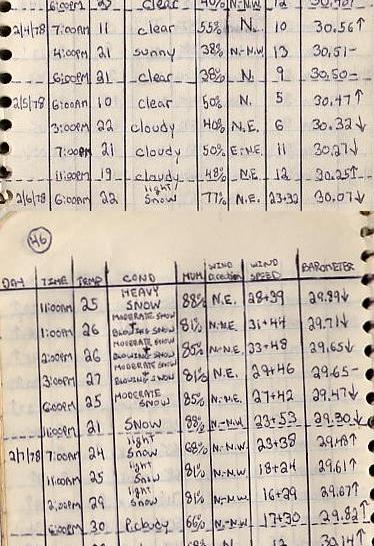
The journal excerpt on the right is from Ed Moran's log of reports from Central Park that he picked off the air from a local radio station. He notes:
I think the most impressive thing shown here is the duration of the high winds. I vividly remember taking a walk Monday evening and quickly turning back because I was frightened by the winds. I have no doubt that gusts peaked well over 60 mph where I was. The most enduring memory I have of the storm is the wind...and most vividly, the noise the wind made roaring through the trees I was walking under that evening. I can still picture the spot and hear the noise from the instant I got spooked and turned around. Strangely perhaps, that is a cherished memory; I have witnessed nothing like it before or since.
Some worthwhile WWW pages about the blizzard include:
I grew up in the northeast Ohio snowbelt, it's one of the reasons I like snow and one of the reasons I live in New Hampshire (after a snowstorm we get sun!) I'm somewhat surprised that there are relatively few accounts on the web of this storm. It may be that New Englanders are expected to talk and write about the weather. After all, Mark Twain set the standard and set it high.
From a USENET posting quoting Bob Copeland, Boston TV met at the time, comes this very good summary of both predictions and impact. The selective memory Bob mentions has also affected him as he merged the previous two storms into one. We think we have it accurate now. While everyone remembers the great blizzard consistently and accurately, the same can't be said about the previous storms. I have no memory of the rain storm, but research I've done and some of my photos make it clear it happened.
From: Donald Rosenfeld
Subject: More on the Blizzard of 78 - Copeland's recollections
Date: 1999/02/27
Newsgroups: ne.weather

-----Original Message-----

:-----Original Message-----
:From: Robert Copeland
:To: DR
:Date: Friday, February 26, 1999 4:36 PM
:Subject: Re: Fw: Have New Englanders turned into wimps?
Hi Donald...
Mr. D seems to suffer from selective memory like most of us, especially when we go back 20 years. For example, the prior "blizzard" of which he speaks was actually closer to 2 weeks prior to the blizzard, on January 20 and set a record for snow in 24 hours in Boston.
Several days later on the 26th, an inland storm brought rain throughout the Boston area, melting most of the snow and creating huge canals everywhere with water flooding many roadways. The resulting mess eventually froze up and formed the base for the "Blizzard of Feb. 6-7". Had Mr. D's "practice blizzard" not mostly washed away, the effects of the February blizzard would have been even MORE incredible!
It would be instrumental to see whether Mr. D watched primarily one channel, or listened to one forecaster in those days, because there WAS a variety of opinion available. And while I do not recollect exactly what everyone else was saying, I DO remember that my dear friend Don Kent was NOT as enthusiastic about the blizzard on that Monday morning as I was. I believe Don was saying something like "there is STILL no indication that" we are going to have a blockbuster storm, though he DID change his mind by midday, as a WALL of heavy snow began moving northward from the NYC area. My recollection is that the storm was VERY WELL forecast. And while NO ONE could have sanely predicted the ultimate magnitude of the snowfall, the snowfall estimates were at the EXTREME end of the range that had EVER been predicted for ANY storm.
The first inklings of the impending MAJOR storm development came as early as Thursday of the week prior to the blizzard. The long range progs (in those days the max. was 48 to 72 hours) were suggesting a strong short wave would be digging southeastward through the Great Lakes toward the east coast into a very favorable temperature environment, and we began to hint at a MAJOR snowstorm for early the following week. As each run of the progs over the weekend confirmed our earlier thinking, Mark Rosenthal, who was working my radio stations for me called me at home to say he was going to go for ONE TO 2 FEET OF SNOW! I told him that was outrageous, but I agreed to come in to the office to look at the progs myself. When I saw the progs, I had to agree there was little reason NOT to make such an "outrageous" forecast, except for the fact that to the best of my knowledge, it had NEVER been done before, certainly not BEFORE a snowstorm had actually commenced.
I came in that Monday morning, about 10 hours before the storm began in the Boston area, and this is what I forecast on the "Eyeopener": a storm of "historic" proportions; I pointed out that the benign cloudy sky of the early morning would give way to HEAVY snow in the afternoon, and suggested that if folks felt COMPELLED to go to work as usual, that they could expect to deal with serious driving problems on the way home; I stuck with the 1 to 2 feet of snow forecast that Mark had issued Sunday, and forecast winds of near hurricane force would cause massive drifts; along the coast, taking note of the new moon" tides which were going to be about 12' under the best of circumstances, I forecast RECORD high tides along the coast, and predicted that this would turn out to be the most serious threat to life and property. John Coleman, who was the forecaster on "Good Morning America" (or whatever the ABC Network morning program was called in those days) called me in the office about 7 am, and asked me what I was forecasting for Boston. I gave him all the above information, and suggested he emphasize the special flooding dangers along the coast.
Not only did he upgrade his forecast almost completely along the lines I suggested, but he credited me personally on nationwide TV (which I found very flattering). Well, we all know the results, folks who did NOT heed the early warnings had a horrendous time getting back home. By the time I was able to leave Ch. 5 about 2 PM, the "wall" of snow had arrived, and because I chose to take a short detour for some food on the way home, I wound up taking almost an hour to drive to my home only a mile away! During the evening commute, a truck skidding accident on the southbound side of Rte. 128 near route 138 in Milton started the progressive backup in traffic which eventually resulted in the most monumental marooning of people in automobiles in the history of Massachusetts. And you probably remember the TV images of the heroic rescues of people wading up to their armpits in freezing slush-filled salt water along the shore fromRevere to Hull. A record high tide indeed. Hurricane force winds indeed. One to 2 feet of snow forecast...on the average, an amazing forecast in my opinion. To be sure, many places had MORE than 2 feet; we had about 34" in Needham, to the best of my measuring ability. The max amounts were just to the south and southwest uf us in a band down through Dedham, Sharon, Norwood on to a little area of perhaps 50 to 55 inches in northernmost Rhode Island. I was one of only 2 Ch.5 employees (other than those who were put up in the hotel across Rte. 128) who made it into work on Tuesday morning; I came in on SNOWSHOES! What a storm!
So, while I was surely very personally involved, (and perhaps it could be said that I "have an axe to grind") and even given the technological improvements of the 21 years since, I doubt whether there will EVER be a major natural event as well forecast as the "Blizzard of '78". JMHO.
Bob
[2010 Mar 2: Note to people who've left New England and may not have heard, Don Kent retired in 1983 and spent the rest of his life in NH. He died last night at age 92. It's unlikely anyone will ever live through another period of such rapid change in meteorolgy.]
Todd Gross' comments from 2006:
Subject: [toddgross] Re: Blizzard of 1978 - so what did the
  forecast call for the day before the blizzard
From: Todd Gross
Date: Wed, 8 Feb 2006 09:50:18 -0800 (PST) (12:50 EST)
To: ..., toddgross support group at yahoogroups.com
My morning forecast (WRKO MUSIC RADIO) carried through to Noon on 2/6/78 was for 12-18" of snow in a massive storm. Harvey Leonard on WNAC-TV7 went 8-14" in a massive storm.
Apparently the old school forecasters missed it entirely.. I always kicked myself for not going the 1-2' that I did in NYC. It was a "computer generated" LFM [Limited Fine Mesh] model storm that looked suspicious, but once the heavy snow started in Baltimore, Philly and then NYC it was a piece of cake. It was the first ever computer model success story.
Todd
Subject: Off Topic - 78 Blizzard Hourly Snowfall at Woonsocket, RI
From: "Arthur Cadoret"
Date: Tue, 21 Jan 2003 09:21:58 -0500
To: WXOBS-SNE@shore.net

In view of recent discussions here and upcoming 25th anniversary, I am copying
below the hourly snow totals straight from our weather records:

Monday, February 6, 1978 REPORT OF SNOWFALL RECORDED AT START OF
EACH HOUR SINCE 10:30 A.M.
             11 AM 0.3 IN.                    6 PM 11.4 IN.
             12 N  2.2 IN.                    7 PM 13.0 IN.
             1  PM 3.8 IN.                    8 PM 13.5 IN.
             2  PM 5.5 IN.                    9 PM 14.1 IN.
             3  PM 7.4 IN.                   10 PM 14.5 IN.
             4  PM 8.8 IN.                   11 PM 14.7 IN.
             5  PM 9.8 IN.                   12 M  15.2 IN.
BLIZZARD WARNINGS IN EFFECT AND AT MIDNIGHT WIND GUSTING 35 TO 60
MPH


Tuesday, February 7, 1978 REPORT OF SNOWFALL TOTAL AT START OF EACH
HOUR BEGINNING 1:00 A.M.
               1 AM  16.0 IN.          12 N   29.3 IN.
               2 AM  17.3 IN.          1 PM   29.8 IN.
               3 AM  18.5 IN.          2 PM   30.5 IN.
               4 AM  19.4 IN.          3 PM   31.3 IN.
               5 AM  20.3 IN.          4 PM   31.7 IN.
               6 AM  21.9 IN.          5 PM   32.2 IN.
               7 AM  23.6 IN.          6 PM   32.6 IN.
               8 AM  25.0 IN.          7 PM   32.8 IN.
               9 AM  26.0 IN.          8 PM   33.0 IN.
              10 AM  27.1 IN.          9 PM   33.1 IN.
              11 AM  28.5 IN.         10 PM   33.2 IN.
Contact Ric Werme or return to his home page.
Created 2003 February 1, last edit 2023 June 25.
Be sure to visit my personal account
from Marlboro Massachusetts.